As a delegate to the Candlewood Lake Authority I’ve been collecting water quality data in Candlewood Lake since June 2020. Twice a week (more or less) I’ve dropped a probe into the middle of the lake off my waterfront and at 1 meter intervals recorded temperature, dissolved O2, specific conductivity (essentially salinity), pH, and chlorophyll and blue green algae concentrations.

I use a "Manta 40" probe, and off season access the sampling sites with small trailored aluminum runabout.
In the fall, as the lake loses heat to the cooler air above it, the cooled water sinks until it meets even cooler water below. Eventually, the surface temperature approaches the bottom temperature. The temperature of the lake becomes uniform, and the lake begins to “turn over” as cold bottom waters are replaced by even cooler water from the surface. At this point, the lake is well mixed and very uniform in temperature and composition. By 11/03, there was virtually no stratification in the water column, and things remained that way through 11/19 as the water continued to cool.

On 11/25, a new and unexpected thermocline (a boundary layer between warm water above and cooler water below) appeared at a depth of about 11m. The colder water below the thermocline was “saltier” (as indicated by a higher specific conductivity) and enriched with O2, as if a new body of water had been introduced at the bottom of the lake. The "discovery data" appears below, with the thermocline indicated by a blue line.

I assumed that I had sampled water that the power company that operates the lake had recently pumped up from the Housatonic River. The pumping station is about 2 1/2 miles north of the sample site. I did another sampling the morning of 11/28, and once again saw the thermocline.
To confirm my assumption, I (with the encouragement and help of an enthusaistically interested friend) hustled down to a bridge over the Housatonic near the intakes at the power company’s pumping station. Dodging traffic, we dropped the probe over the side of the bridge and made the following measurements:

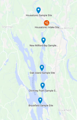
It seemed like a close match to water I'd observed at the bottom of the lake earlier that day, so my next thought was to map the pumped water as it moved southward and mixed with the lake water. I chose four sampling sites as shown on the map to the right, and headed out the next day to sample them.
Pumped in at the northern end of the lake, the colder Housatonic water apparently formed a lens of cooler, saltier water that hugged the bottom of the lake as is spread southward. I drew this profile from the data I collected on 11/29/2020 at the four sites. (Data set is here t.ly/1E9g )

As the slug of cool water spilled southward it warmed as it gained heat from the water above it. By the time it reached Brookfield, almost 6 miles to the south, it had largely dissipated into the surrounding waters. By 12/10/2020 there was no trace of it south of The Narrows, though the specific conductivity of the water there was slightly higher than it was prior to the pump up.